


Weekend forecast calls for more snow and lower temperatures
• Low-Impact Winter Storm Sunday & Monday for AEP’s East Utilities
• Extreme Cold Wave Monday & Tuesday
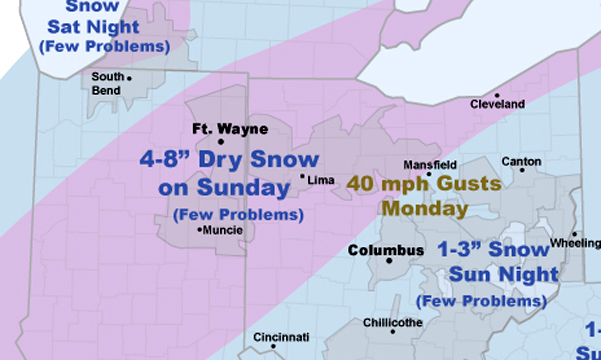
AEP has issues a weather advisory, which affects the Icon viewing area. Here is the information provided by AEP. The map above relates to this information.
AEP meteorologists expect another low-impact winter storm will track through AEP’s East Utilities on Sunday followed by bitterly cold temperatures and gusty winds Monday.
Preliminary information suggests roughly 4-8 inches of dry snow will fall across Indiana and northwest Ohio on Sunday. Over eastern Ohio rain will change to 1-3” of dry snow Sunday night. The precipitation could even start as some light freezing rain Sunday morning over western Virginia (Roanoke),but amounts look negligible. The dry nature of the snow should preclude any significant utility problems.
Bitter cold temperatures and strong west winds will overspread AEP’s East utilities on Monday. Current data suggests the wind speeds will peak near 45 mph, just under problematic thresholds for the utilities.
However, Monday may be the coldest day for AEP Ohio since January, 1994.
Temperatures over western Ohio could remain below 0 F all day Monday. Expect dangerous wind chills of -25F to -40F.
Section: News in
Stories Posted This Week
Friday, July 11, 2025
Thursday, July 10, 2025
Wednesday, July 9, 2025
- Home cooling assistance program through Sept. 30
- Alfes named Women's Golf Coaches Association All-American Scholar for 2024-25
- Library staff will kiss a frog if patrons check out 1,000 books
- Red, White, Woof pup adoption party on July 12
- Expectations, communication feature in public meeting about N. Gilbert St. parking
- Ada Athletic Boosters prepare for 2025-2026 sports programs
- The Icon's menu mission
Tuesday, July 8, 2025
Monday, July 7, 2025
- Special Board of Education executive session, July 8
- Funeral arrangements for Vera Marie Sprague
- Hardin County specialty crop walk on July 9
- Private family services will be held for Mary Lou Reffitt
- Varsity Singers Community performance July 10
- Ada Board of Education approves waiver of school fees for 2025-2026
- July 12 Ice Cream Open House at Grace Gospel Church